

Our Services
Stockpile Volume Analysis
With the use of our Unmanned Aerial Vehicles, we are able to gather highly detailed and precise measurements and in turn provide accurate volume calculations for stockpiles. This non-invasive analysis is safe and allows a company to continue to operate as normal. Our drones can collect data in hours what a manned crew would in days. This benefits corporations by providing a transparent evaluation of inventory levels for financial reports and provides data to help manage purchasing and stock logistics.
Land Survey
With the use of geo-referenced imaging and elevation data, Topview Inspection can provide high quality aerial mapping that exceeds that of common methods. With a special colour gradient overlay system to help readers of the report understand the significance of certain geographical features. This is a very cost-effective and superior alternative to the traditional methods.
Infrared Thermography
Our UAV’s are equipped with the latest innovative technology to provide imaging solutions that were previously mostly ground based imaging. We provide effective leak detection imaging, heat loss analysis for residential commercial and industrial properties at a fraction of the cost of alternative methods. These analytics are used for comprehensive reports outlining key issues while providing innovative solutions per client basis.
Aerial Photography
Get the most out of your property or event with UAV cinematography. We provide the highest quality professional aerial photography and video editing services. Perfect for real estate promotions and specialized web based or television based advertisements. Please let our team of professionals curate a perfect video solution exact to your specifications.
Aerial Inspection
Using aerial drones to visually inspect tall or difficult to reach structures as an alternative to traditionally expensive and dangerous work. Our drones are equipped with ultra high-resolution cameras to capture high-quality photos and videos to provide data to assess the structural integrity without ever leaving the ground. This process is highly beneficial as it saves time, the process requires only a few hours, and also inexpensive compared to alternative methods.
Emergency Response
Topview Inspection has the capabilities to assist emergency response personnel with a bevy of items. From non-invasive crime-scene investigations, to traffic accident reporting, to search and rescue missions. Our UAV is equipped with the best in new technology to perform tasks that will not contaminate crime scenes and could ultimately save a life. Please let us know if we can help your emergency response team.
Interested in Our Equipment? Check Out Our Fleet!
Draganfly Commander
The most advanced UAV in the industry, our Draganfly Commander has a single-charge flight time of 45 minutes, can provide over 100 acres of coverage and equipped with HD aerial data capture. This drone is perfect for a variety of commercial uses such as:
- Stockpile Volume Analysis
- Land Survey
- Infrared Thermography

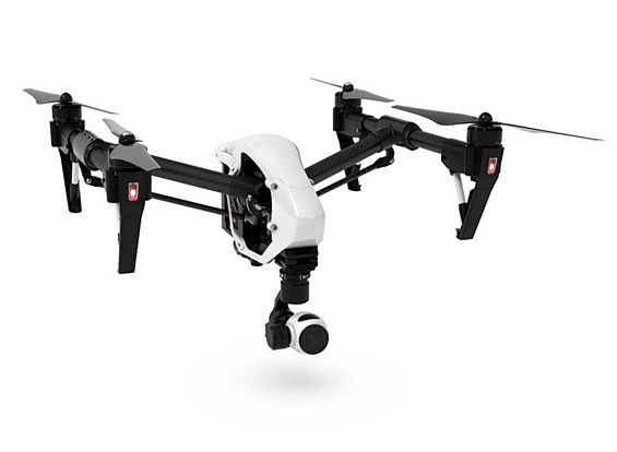
DJI Inspire 1
Our Inspire 1 is designed to be a powerful, lightweight, and stable UAV. Equipped with the flexibility to take unobstructed 360 degree photos, 4k video capture and autonomous flight. This UAV is perfect for a bevy of services including:
- Aerial Inspections
- Surveying and Mapping
- Real Estate Cinematography
Our Company
Topview Inspection is a Toronto based commercial aerial drone service provider using remotely piloted Unmanned Aerial Vehicles. We provide services across all of Ontario. Our services range from real estate photography to land survey and infrared leak detection using detailed analytics generated by our state of the art equipment along with specialized software.
Our crew comes from a construction background with over 40 years in the industry. They have trained eyes to locate and pinpoint problem areas in their inspections as well as the knowledge to provide a detailed report to communicate their findings clearly and in a concise manner.
The inspection process includes:
1. License Acquisition – Application to obtain a permit to fly at the site.
2. Pre-Flight – Site visit and pre-inspection of site and surrounding area.
3. Inspection – Use of the UAV to collect and record data.
4. Report – Provide a detailed report with regards to the client’s request.
Topview Inspection is always looking to build great relationships with their clients and is home to professional and courteous staff. We look forward to working with you.
All flight programs are planned in compliance with Transport Canada and an SFOC (Special Flight Operations Certificate) will be acquired.